![]()
location-conflation
What is it?
Location-conflation is a tool for generating GeoJSON features by including and excluding other locations and shapes.
It is useful for generating geofences in a declarative way, so your application doesn't need to bundle or fetch so much geodata.
You can define a locationSet as an Object with include and exclude properties:
const locationSet = {
  include: [ Array of locations ],
  exclude: [ Array of locations ]
};
The "locations" can be any of the following:
-
Strings recognized by the country-coder library.
These include ISO 3166-1 2 or 3 letter country codes, UN M.49 numeric codes, and supported Wikidata QIDs.
Examples:"de","001","conus","gb-sct","Q620634"
👉 A current list of supported codes can be found at https://ideditor.codes -
Filenames for custom
.geojsonfeatures. If you want to use your own features, pass them to the LocationConflation constructor in aFeatureCollection
EachFeaturemust have anidthat ends in.geojson.
Examples:"de-hamburg.geojson","new_jersey.geojson" -
Circular areas defined as
[longitude, latitude, radius?]Array.
Radius is specified in kilometers and is optional. If not specified, it will default to a 25km radius.
Examples:[8.67039, 49.41882],[-88.3726, 39.4818, 32]
Installing
Use in Node
npm install @ideditor/location-conflation
location-conflation is distributed in CJS and ESM module formats for maxmimum compatibility. (Read more about Javascript module formats)
const LocationConflation = require('@ideditor/location-conflation').default;  // require CJS
// or
import LocationConflation from '@ideditor/location-conflation';   // import ESM
Use in Browsers
You can also use location-conflation directly in a web browser. A good way to do this is to fetch the "iife" bundle from the jsDelivr CDN, which can even deliver minified versions.
When you load this file in a <script> tag, you'll get a LocationConflation global to use elsewhere in your scripts:
<head>
<script src="https://cdn.jsdelivr.net/npm/@ideditor/location-conflation@1.1/dist/location-conflation.iife.min.js"></script>
</head>
…
<script>
  var loco = new LocationConflation.default();
</script>
Examples
const LocationConflation = require('@ideditor/location-conflation').default;
const myFeatures = require('./path/to/FeatureCollection.json');   // optional
const loco = new LocationConflation(myFeatures);
Southern Europe:
const locationSet = { include: ['039'] };    // 039 = Southern Europe
const result = loco.resolveLocationSet(locationSet);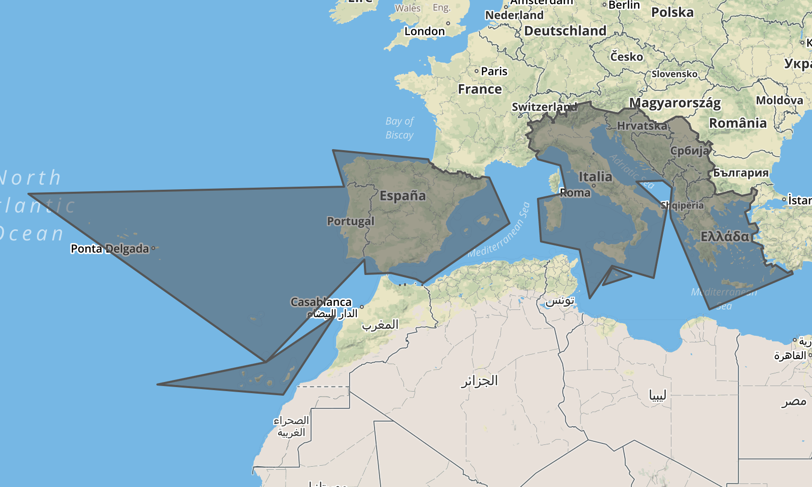
Southern Europe and Northern Africa:
const locationSet = { include: ['039','015'] };   // 015 = Northern Africa
const result = loco.resolveLocationSet(locationSet);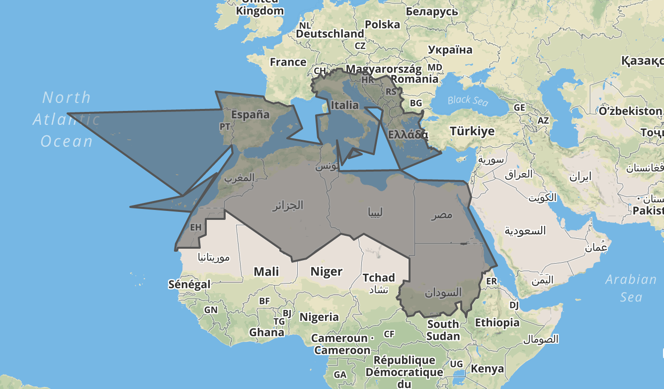
Southern Europe and Northern Africa, excluding Egypt and Sudan:
const locationSet = { include: ['039','015'], exclude: ['eg','sd'] };
const result = loco.resolveLocationSet(locationSet);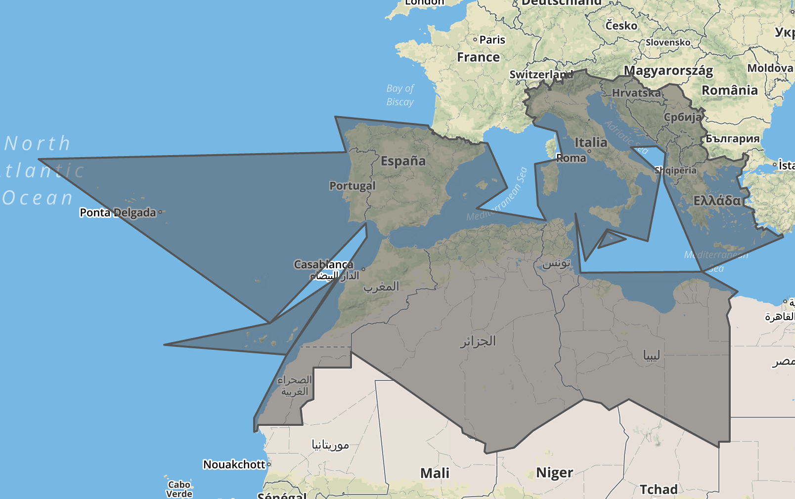
The Alps, excluding Liechtenstein and regions around Bern and Zürich
const result = loco.resolveLocationSet({ include: ['alps.geojson'], exclude: ['li', [8.55,47.36], [7.45,46.95]] });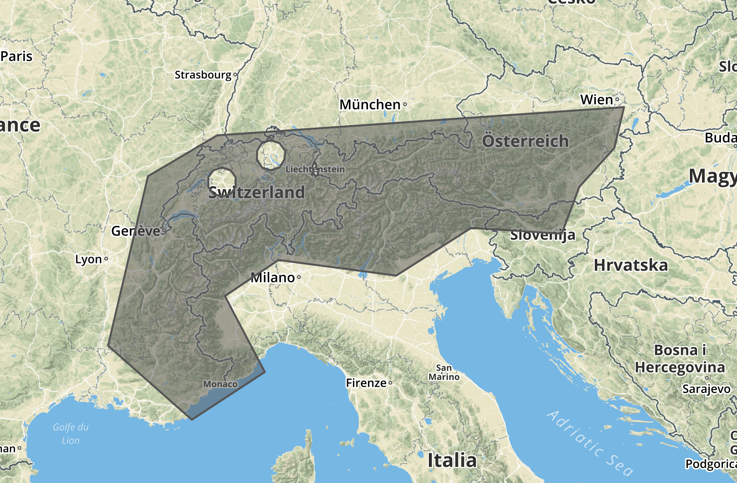
API Reference
- constructor
- validateLocation
- validateLocationSet
- resolveLocation
- resolveLocationSet
- strict
- stringify
- cache
# const loco = new LocationConflation(featureCollection)
Constructs a new LocationConflation instance.
Optionally pass a GeoJSON FeatureCollection of custom features which can be referred to later as locations.
Each feature must have a filename-like id, for example: new_jersey.geojson
{
  "type": "FeatureCollection"
  "features": [
    {
      "type": "Feature",
      "id": "new_jersey.geojson",
      "properties": { … },
      "geometry": { … }
    }
  ]
}
# loco.validateLocation(location)
Validates a given location. The "locations" can be:
-
Strings recognized by the country-coder library.
👉 A current list of supported codes can be found at https://ideditor.codes
Examples:"de","001","conus","gb-sct","Q620634" -
Filename-like identifiers of custom
.geojsonfeatures.
Examples:"de-hamburg.geojson","new_jersey.geojson" -
Circular areas defined as
[longitude, latitude, radius?]Array.
Radius is specified in kilometers and is optional. If not specified, it will default to a 25km radius.
Examples:[8.67039, 49.41882],[-88.3726, 39.4818, 32]
If the location is valid, returns a result Object like:
{
  type:     'point', 'geojson', or 'countrycoder'
  location:  the queried location
  id:        the stable identifier for the feature
}
If the location is invalid,
- in strict mode, throws an error
-
in non-strict mode, returns
null
# loco.validateLocationSet(locationSet)
Validates a given locationSet. Pass a locationSet Object like:
{
  include: [ Array of locations ],
  exclude: [ Array of locations ]
}
If the locationSet is valid, returns a result Object like:
{
  type:         'locationset'
  locationSet:  the queried locationSet
  id:           the stable identifier for the feature
}
If the locationSet is invalid or contains any invalid locations,
- in strict mode, throws an error
-
in non-strict mode, invalid locations are quietly ignored. A locationSet with nothing included will be considered valid, and will validate as if it were a locationSet covering the entire world.
{ type: 'locationset', locationSet: ['Q2'], id: +[Q2] }
# loco.resolveLocation(location)
Resolves a given location into a GeoJSON feature. This is similar to validateLocation, but runs slower and includes the actual GeoJSON in the result. Results are cached, so if you ask for the same thing multiple times we don't repeat the expensive clipping operations.
The returned GeoJSON feature will also have an area property containing the approximate size of the feature in km². (This is helpful for sorting features)
If the location is valid, returns a result Object like:
{
  type:     'point', 'geojson', or 'countrycoder'
  location:  the queried location
  id:        the stable identifier for the feature
  feature:   the resolved GeoJSON feature
}
If the location is invalid,
- in strict mode, throws an error
-
in non-strict mode, returns
null
# loco.resolveLocationSet(locationSet)
Resolves a given locationSet into a GeoJSON feature. This is similar to validateLocationSet, but runs slower and includes the actual GeoJSON in the result. Results are cached, so if you ask for the same thing multiple times we don't repeat the expensive clipping operations.
The returned GeoJSON feature will also have an area property containing the approximate size of the feature in km². (This is helpful for sorting features)
If the locationSet is valid, returns a result Object like:
{
  type:         'locationset'
  locationSet:  the queried locationSet
  id:           the stable identifier for the feature
  feature:      the resolved GeoJSON feature
}
If the locationSet is invalid or contains any invalid locations,
- in strict mode, throws an error
-
in non-strict mode, invalid locations are quietly ignored. A locationSet with nothing included will be considered valid, and will validate as if it were a locationSet covering the entire world.
{ type: 'locationset', locationSet: ['Q2'], id: +[Q2] }
# loco.strict(val)
Get/set "strict mode". New instances of LocationConflation start out in strict mode by default.
- In strict mode, any invalid location or locationSet throws an error.
- In non strict mode, invalid locations are ignored, and locationSets that include nothing are assumed to include the entire world.
loco.strict(false);                // pass a true/false value to set the strict mode
const isStrict = loco.strict();    // pass no value to return the current value
# loco.stringify(object, options)
Convenience method that wraps json-stringify-pretty-compact to stringify the given object. Optional options parameter gets passed through to json-stringify-pretty-compact.
loco.stringify(someGeoJson, { maxLength: 100 }); // Make it pretty!# loco.cache()
Convenience method to access the internal feature _cache. You probably shouldn't use it except for debugging.
Contributing
Prerequisites
Installing
- Clone this project, for example:
git clone git@github.com:ideditor/location-conflation.git -
cdinto the project folder, - Run
npm installto install libraries
Building
npm run build
Thanks!
location-conflation is really just a wrapper around these other great projects:
- country-coder for world boundaries, and
- polygon-clipping for union/difference functions
License
This project is available under the ISC License. See the LICENSE.md file for more details.